These 3 days have exemplified the extremes that often occur during PAC Tour. Each respective day might be described as windy struggle, downhill fun, and spectacular scenery.
This was not a wind day from hell, but we got glimpses of it much too often. Fortunately, the first 35 miles got us started with a smart tail wind and generally downhill route. With this to blow us down the road, many riders got to the location of the first snack stop and passed it by before it opened. Because of our speed, this wasn't a problem: most everyone had snacks and enough water. About six miles later, a couple of dozen riders descended on a Little America where we got set up for our next leg. It was to be our last leisurely stop for the day.
From there, we got on I-80 for a few miles and then turned off to go general west. It's not likely that the wind shifted immediately, but it seemed that as we left Little America, our tail wind turned into a 3/4 headwind. We'd seen similar winds, but not this constant and not one we had to deal with for 70 miles. This was a struggle for experienced pace line riders and even more difficult for single riders. The result was a sag from the next snack stop or lunch for quite a few riders whose energy levels were lagging or who felt they'd be smart to let their minor illnesses or injuries heal. But there were plenty of gutsy riders who persevered all the way to the hotel. The day's last leg gave these riders a small relief by being north for about 30 miles, but then came the "sting in the tail," a final, 20-mile leg that was west-northwest. Even though Montpelier has only one Best Western, it was the "best" Best Western for many.
The worst of the winds were saved for the stretch just after lunch. By now, they were almost a dead on headwind at a steady 30 mph. At times, the landscape would provide a brief respite, but it also provided "tunnels" through which the wind was even worse. I encountered a near dead calm as I started over a railroad bridge over 90 miles into the ride, but before completing the traverse a sustained gust of around 60 mph threatened to pick my quivering bicycle up off the pavement.
Even though this is a relatively short, unchallenging day, our schedule
got us on the road at 6:30. Lon and Susan's idea was to get in early and
see the sights of Wyoming's tourist mecca, Jackson.
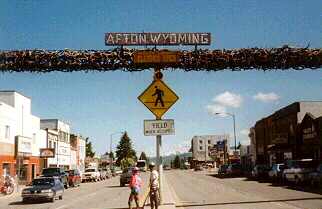
After many uncooperative weather days, today found us with a chilly, 31 degree start; two minor passes (6,938 and 7,630 feet); and, following this warmup, a gracious tail wind. Most of the 3600 feet of climbing took place in the first 30 miles, so we had smooth sailing after the last climb as we sped for 45 miles though Wyoming's Star Valley. In addition to bright green fields and forests, we got a biker's eye view of the valley's quaint towns, including Smoot, Afton, Thayne, Etna, and Alpine. We turned east at Alpine and headed up the Grand Canyon of the Snake River. The road up this narrow canyon took us alternately high above the river and down nearly to the shore. We could see kayakers and boatloads of rafters floating this popular river, which we followed all the way to Jackson. Each of us kept our fingers crossed for favorable winds and clear skies. This wishful thinking apparently paid off as our day finished earlier than usual and left plenty of time to explore the nouveau cowboy town that Jackson has become over the last 15 years.
With probably the steepest continuous climb so far, our early morning
departure from Jackson gave us only a few miles to warm up (problematic
when the temperature is in the upper 30's). But after just 7 miles into
the day, we started up Wyoming's Teton Pass, a 5.5-mile, steady 10% climb
that took us high above the broad valley south of Jackson. Mist over the
lowlands and a sparkling sun were welcome distractions from our grind up
the mountain. On the other side, a 12-mile descent gave us a chance to
catch our breath before the first snack stop in Victor ID. Even though
we start and end outside of Idaho, we spent miles 19 through 126 in my
adopted state. I had been spreading the word that good weather would
make this day of 135 miles and 6,000 feet of climbing a pleasurable ride.
Luckily, clear skies and generally favorable winds helped everyone
appreciate the views. From just north of Victor until we were deep in the
woods climbing the Yellowstone caldera, we could see the west range of
the Teton Mountains.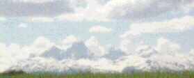 Almost all of the famous pictures of the Tetons
are of the east slopes, but everyone agreed that this crystal-clear day
left little to be desired in the way of snow-capped jagged mountains.
Almost all of the famous pictures of the Tetons
are of the east slopes, but everyone agreed that this crystal-clear day
left little to be desired in the way of snow-capped jagged mountains.
Our route took us through rolling farmlands and backroads. These hills and pine forests have become a major summertime playground for hikers, mountain bikers, and tourists. Because it's still early in the high country summer, we had hardly any traffic until we turned onto the main highway to West Yellowstone. There was one more small pass to climb (which was also the continental divide and the Montana border) and then a downhill/flat run to end the day. A local restaurant owner said the next several days were supposed to be like this one--cheers all around.