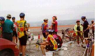
These four days have been the introductory shakedown for many of us, both in a physical, mechanical, and organizational sense. We have a limited time each evening and each of us has to decide what minor aches and pains need to be dealt with so they won't become major problems later, what bike adjustments need to be made now and what can wait, and what changes need to be made in how we get ready and what we carry. Everyone has settled more or less into routines and fiured out what seems to work best. No doubt, though, each of us will have to be flexible as the tour goes on. Here's some day-by-day impressions.
This day was an hors d'oeuvre for our trip--only 60 miles and 1600 feet
of climbing. Our only climb takes us above El Paso, above the city's
brown and yellow haze and between glaring brown rock walls. Once past
the climb, we see small communities and houses, many influenced by
Hispanic history. We roll by the Lost Lizzard Lounge and signs for
"fresh barbacoa". There's Stahman farms (world's largest single producer
of pecans). It seems like miles of shaded, smooth blacktop with
manicured rows of great bowing pecan trees. Here, the temperature must
be 10 degrees cooler than away from the trees. Some of us wondered what
the trip would be like if it were all this temperature--boring probably,
but we also knew we'd probably look on this wisfully when we were baking
on 6% climbs with no shade in sight.
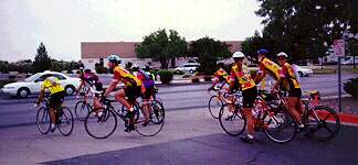
Today was the first "real" PAC Tour day. A mostly flat ride took us north out of Las Cruces, but with a mild haze and moderate temperatures, we enjoyed the ride. Up to 75 miles, we had climbed only about 1000 of our 6650 feet for the day. Our lunch was in a shaded copse in the town of Hillsboro (Lon commented that a town named Hillsboro probably wasn't surrounded by prairie.) There were smooth roads and steady climbs with exciting descents for most of the rest of the day, up and down through sagebrush, pine forests, and red rock outcrops.
Another tough day of climbing and long distance. But the wind was in our favor and the scenery was grandiose--scenic overlooks just made us shake our heads in wonderment. The descents rewarded our work with swooping smooth 40+ mph turns. The two biggest climbs brought us to Saliz Summit in the midst of pine forests and then to a summit whose name I did not get. Together, these accounted for some 3,000 feet of elevation. The latter summit came after a 10-mile climb following lunch: Susan's World Famous Toasted Cheese Made-to-Order Sandwiches. Afterwards, we spent 30 up-and-down miles gradually descending to Springerville AZ.
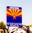
Today, this could have been called The Tailwind Tour. We left Springerville AZ under clear skies and upper 40's and we immediately greeted with a mild wind at our backs. For the first 90 miles or so, we cruised undulating roads with sparse traffic and many of those who did pass honked friendly greetings. The group I was with (by no means a "fast" group) covered the first 28 miles to the rest stop and averaged more than 21 miles an hour with little enough effort to carry on running conversations, mostly on our good fortune. As we headed on toward the next stop, we went through the sleepy town of St Johns (founded 1874). I'm sure it was happenstance, but our passage was greeted by clear peals from the bells of the town's Catholic churches.
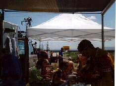 Lunch was between the
state markers for AZ and NM--we half expected to see a state line painted
across the road. By now, the temperature had gotten warm enough for most
of us to gather underneath the white lunch tent for our chicken salad
sandwiches and leftover pasta salad (the best kind). The wind picked up
even more as we left, but the hills seemed larger and steeper; with no
headwind at all, sweat doesn't evaporate as quickly, so everyone's
clothes and black helmet straps soon sported blotches of crusty salt. At
mile 90, the route card said we should take a cutoff road to the left
and, to make sure we did, someone had painted a turn arrow in the road,
along with the words "OK for bikes". Like good PAC Tour, we followed the
arrow and, after a mile or so, a Road Closed sign appeared, which we went
around. Then we had the luxury of no cars at all. As we went, though,
we soon had no road at all: Heavy equipment and a berm halted just about
anything motorized and then we understood "OK for bikes". The road was
hard-packed dirt for the most part, so we all had loads of fun bouncing
around (the mountain bikers more than the pure road riders) for a few
miles before we connected to the paved road. The last 30 miles were more
of the same, only better--stronger tailwind and bigger hills. When we
arrived in Gallup, many of us took the downtown route to see some sights
before the El Rancho Hotel, which calls itself the "Home of the Movie
Stars" and has movie star motifs throughout the rooms and lobby. Our
favorable winds and lack of big climbs let many of us take care of
washing and other needed chores.
Lunch was between the
state markers for AZ and NM--we half expected to see a state line painted
across the road. By now, the temperature had gotten warm enough for most
of us to gather underneath the white lunch tent for our chicken salad
sandwiches and leftover pasta salad (the best kind). The wind picked up
even more as we left, but the hills seemed larger and steeper; with no
headwind at all, sweat doesn't evaporate as quickly, so everyone's
clothes and black helmet straps soon sported blotches of crusty salt. At
mile 90, the route card said we should take a cutoff road to the left
and, to make sure we did, someone had painted a turn arrow in the road,
along with the words "OK for bikes". Like good PAC Tour, we followed the
arrow and, after a mile or so, a Road Closed sign appeared, which we went
around. Then we had the luxury of no cars at all. As we went, though,
we soon had no road at all: Heavy equipment and a berm halted just about
anything motorized and then we understood "OK for bikes". The road was
hard-packed dirt for the most part, so we all had loads of fun bouncing
around (the mountain bikers more than the pure road riders) for a few
miles before we connected to the paved road. The last 30 miles were more
of the same, only better--stronger tailwind and bigger hills. When we
arrived in Gallup, many of us took the downtown route to see some sights
before the El Rancho Hotel, which calls itself the "Home of the Movie
Stars" and has movie star motifs throughout the rooms and lobby. Our
favorable winds and lack of big climbs let many of us take care of
washing and other needed chores.